|
 |
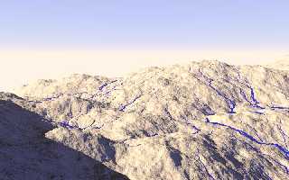
I've got a paper due, so once again I am POV-ing.
I'm trying to calculate the flow of water across a terrain, so that hopefully I
could eventually add realistic rivers, gullies, and ponds to a terrain. It
ought to be possible to feed the water flow information back into the function
used to create the terrain itself, to create erosion.
So far, my code simply picks a random starting point, checks the altitude of
points around it, and chooses the lowest point. Then it repeats, creating cones
to indicate its path.
When the lowest new point is higher than the current point, water ought to
collect. I've tried adding code to create ponds where the water ought to
collect, but I'm running into weird problems.
I'm posting in the hopes that perhaps some of the brilliant minds around here
could improve upon what I'm doing. In fact, I'd be surprised if no one around
here has tried this before, but I couldn't find anything like it yet.
Post a reply to this message
Attachments:
Download 'water201.jpg' (72 KB)
Preview of image 'water201.jpg'
|
|


